
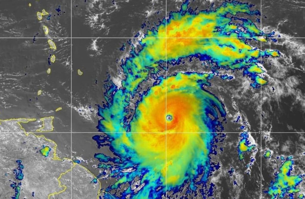
Beryl is now a Category 4 Hurricane as it is projected to make landfall in the Windward Islands early on Monday morning, July 1st 2024.
A Tropical Storm Watch is in effect for Trinidad. This means that tropical storm conditions, including “sustained winds” of 63-118 km/h, are possible somewhere within the watch area within the next 18 hours.
There is a medium chance (35-55%) of tropical storm force winds affecting Trinidad, particularly in the northern and eastern areas, from early morning on Monday, 1st July, as Beryl approaches the southern Windward Islands.
By 6 pm this evening, sea conditions are expected to become rough with large, battering waves. Heavier rainfall and thunderstorm activity are anticipated towards midnight. Strong wind gusts in excess of 55 km/h, may be experienced ahead of Beryl from this evening.
Tobago is under a Hurricane Warning as Beryl has maximum sustained winds near 215 km/h with higher gusts. This means there is a higher potential for hurricane conditions, including sustained winds in excess of 118 km/h, within the warning area, in this case within the next 18 hours.
Tobago can expect a gradual deterioration in conditions beginning with periods of showers and gusty winds in excess of 65km/h beginning from early evening today. Sea conditions are also expected to deteriorate with large battering waves affecting all coastlines of the island beginning by late afternoon today.
As Beryl approaches the southern Windwards, there is a high chance (80%) of hurricane force winds impacting Tobago from early morning Monday 01st July. The next update will be at 5 pm today (Sunday 30th June 2024) or earlier if necessary.
SUMMARY OF WATCHES AND WARNINGS IN EFFECT:

A Hurricane Warning is in effect for...
* Barbados
* St. Lucia
* St. Vincent and the Grenadine Islands
* Grenada
* Tobago

A Tropical Storm Warning is in effect for...
* Martinique

A Tropical Storm Watch is in effect for...
* Dominica
* Trinidad
Hurricane conditions are expected in the hurricane warning area beginning early Monday morning. Potentially catastrophic wind damage is expected where the eyewall of Beryl moves through portions of the Windward Islands, with the highest risk of the core in St. Vincent and the Grenadines, and Grenada.
Wind speeds atop and on the windward sides of hills and mountains are often up to 30 percent stronger than the near-surface winds indicated in this advisory, and in some elevated locations could be even greater.
Hurricane Beryl is expected to produce rainfall totals of 3 to 6 inches across Barbados and the Windward Islands through Monday. Localized maxima of 10 inches is possible, especially in the Grenadines. This rainfall may cause flash flooding in vulnerable areas.
Here in Trinidad, ODPM CEO Rodney Smart is urging persons to think about their plan for Beryl. He is urging persons to ensure their homes are secure or to consider relocating if needed.
Public Utilities Minister Marvin Gonzales says T&TEC, WASA, TSTT and SWMCOL are all mobilized. He adds that the necessary resources have been put in place to mitigate the impact of any disruptions. No decision on the closing of school has yet been made, up to 2:30pm.
Later this afternoon, the THA will host a media conference regarding Tobago’s preparations for Hurricane Beryl.
Responses