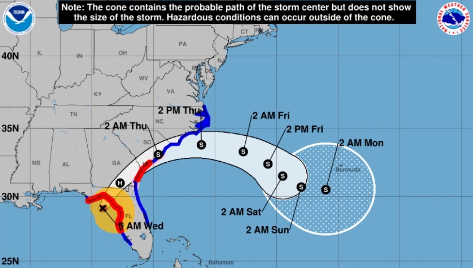
Hurricane Idalia weakened back to a Category 3 storm ahead of landfall in Florida.
Winds have decreased slightly to 201kmph but potentially catastrophic storm surges and destructive winds are still expected.
BBC News says 28 counties in Florida are under some form of evacuation order ahead of landfall expected around 8am.
The following information is from the National Hurricane Centre:
SUMMARY OF WATCHES AND WARNINGS IN EFFECT:
A Storm Surge Warning is in effect for…
* Englewood northward to Indian Pass, including Tampa Bay
* St. Catherine’s Sound to South Santee River
A Hurricane Warning is in effect for…
* Middle of Longboat Key northward to Indian Pass, including Tampa
Bay
A Tropical Storm Warning is in effect for…
* Chokoloskee northward to the Middle of Longboat Key
* West of Indian Pass to Mexico Beach
* Sebastian Inlet Florida to Surf City North Carolina
A Storm Surge Watch is in effect for…
* Bonita Beach northward to Englewood, including Charlotte Harbour
* Mouth of the St. Mary’s River to St. Catherine’s Sound Georgia
* Beaufort Inlet to Ocracoke Inlet North Carolina
* Neuse and Pamlico Rivers North Carolina
A Hurricane Watch is in effect for…
* Mouth of the St. Mary’s River to Altamaha Sound
* Edisto Beach to South Santee River
Furthermore, the NHC says Idalia could continue to strengthen before it reaches the Big Bend coast of Florida.
While Idalia should weaken after landfall, it is likely to still be a hurricane while moving across southern Georgia, and near the coast of Georgia or southern South Carolina late today.
Idalia should emerge off the southeastern United States coast early on Thursday and move eastward through late week.
This article has been updated…
(Photo credit: National Hurricane Centre)


Responses